
Teacher Background Information
What is climate change? 
Climate change is the phenomenon that describes long term changes in average weather conditions. Earth’s average temperature has risen 1.5 °F over the past century, and is expected to rise another 0.5 to 8.6°F in the coming century. This warming of the planet, otherwise referred to as global warming, has significant implications for the planet, influencing not only daily temperatures, but also altering things such precipitation patterns and sea level. While climate change can occur naturally (and has for millions of years in the past), current rates of temperature rise are too rapid to be described by natural forces alone. The activities of humans are largely responsible for causing climate change. The excessive release of greenhouse gases (most notably, carbon dioxide) into the atmosphere from practices such as fossil fuel burning and deforestation, have continuously trapped heat in the atmosphere otherwise known as the greenhouse effect.
Read more at NASA’s Climate Page
What is sea-level rise?
In response to warming temperature on the planet, global sea level has been rising. Over the past century, the global mean sea level has risen by 4 to 8 inches, but has also exhibited an acceleration in the past 20 years. The increase in sea level is primarily due to thermal expansion, and the melting of landbased ice, such as glaciers and ice sheets. The consequences of Increasing sea-level rise include nuisance flooding, saltwater intrusion, damage to ecosystems and increased severity of damage to coastal storms. Locally, the prediction for sea level rise can be different from global estimations due to subsidence, upstream flood control, erosion, regional ocean events, etc.. In North Carolina the sea level is predicted to rise up to 10.6 inches in the Northeastern part of the state.
What are tides?
Tides are a period wave that move through the oceans causing the seas surface to rise and fall. When the crest of the “tidal wave” reaches a particular location this is known as high tide, and the trough of the wave is known as low tide. This pattern is most noticeable along the coastline where the shifting of water can be seen in reference to the water’s height on the beach or coastal structure.
Tides are generated by the gravitational attraction of the moon and Sun on the Earth. Distance is a more highly weighted variable than mass when concerning tidal generation, therefore the moon has the greatest effect on the ocean’s tides than the sun.
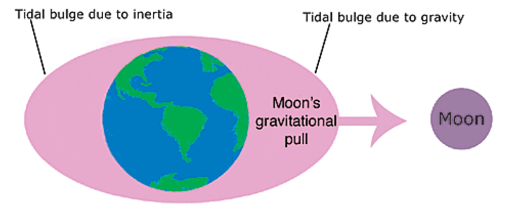
The gravitational pull of the moon is greatest on the side of the Earth that is facing the moon, which causes the water on that side to be pulled toward the moon. Inertia counterbalances the pull of gravity and “attempts” to keep the water in place. On the side of the Earth where the moon is closest, gravity exceeds inertia causing a “bulge” of water on the near side toward the moon. On the opposite side of the Earth inertia exceeds the gravitational pull and keeps the water moving in a straight line creating another bulge.
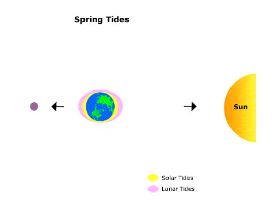
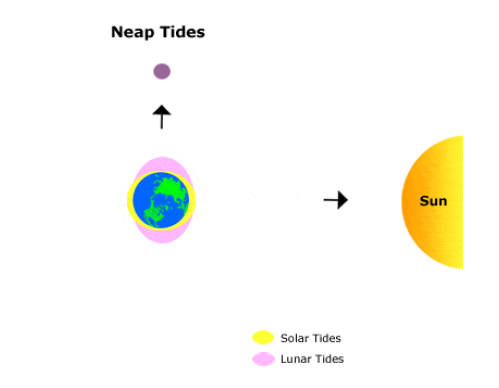
When the Sun, moon, and Earth are all in alignment the “solar tide” has and additive effect on the lunar tide. This creates higher high tides, and lower low tides, both are often referred to as spring tides. When the sun and moon are at right angles to each other the solar tide has an opposing effect on the lunar tide leading to a moderate tidal levels, often referred to as neap tides.
In addition, the sun and moon follow elliptical orbits around the Earth, which also affects tide levels. When the moon is closest to the Earth (perigee) tide generating forces are the greater than usual, and when it’s farthest from the Earth (apogee) tidal forces are smaller than usual. This causes higher and lower than normal tidal ranges. Similarly, when the Earth is closest to the sun tides (perihelion) are higher, and when it’s farther from the Earth (aphelion) tides are lower.

Most coastal areas experience two high, and two low, tide events every lunar day. A lunar day is the time it takes for a specific point on Earth to complete a full rotation in relation to the moon. Unlike the 24-hour solar day that we are all familiar with, a lunar day is 24-hours and 50-minutes. This means that high tides occur every 12-hours and 25-minutes.
The information and pictures from this section were obtained from NOAA
Link to NOAA’s water level stations in North Carolina
http://tidesandcurrents.noaa.gov/map/index.shtml?lat=34.7&lng=-76.6&zoom=8&type=PreliminaryData
More educational resources from NOAA
https://tidesandcurrents.noaa.gov/education.html
King Tides
A king tide, formally known as a perigean spring tide, refers to the highest predicted high tide events of the year. During a king tide, the Sun and Moon are aligned with the Earth, allowing their gravitational pulls to combine. In addition, a king tide occurs when the moon is the closest to the Earth (perigee), and when the Earth is closest to the sun (perihelion), both within their elliptical orbits. King tides are not only characterized by exceptionally high highs, but also exhibit lower than normal lows as the tidal ranges are generally the greatest within the year.
North Carolina King Tides Project
The North Carolina King Tides Project is part of an international citizen science initiative that seeks to engage the public in photo documentation of king tides events. In North Carolina, documentation of water levels is particularly interesting, as meteorological components such as wind speed and wind direction, in addition to astronomical tides (produced by the Sun and Moon), are important contributing factors to the water level of coastal North Carolina. Using cameras and smartphones, participants are asked to record instances of high water events (not just king tides!) along the coast to visualize what a reality with high sea levels might looks like in the future. Participants in the project are asked to take photos, incorporating a ruler in the shot to measure water level and submit their “findings” to a Flickr account.
Check NOAA’s King Tides Project Page to learn more about the global initiative.
The instructions can be found here
The photos should be recorded with details such as the time, date, address, latitude and longitude.